Click to enlarge
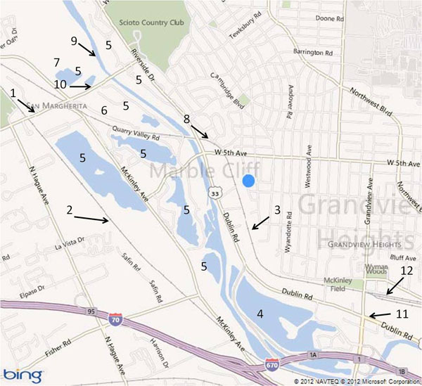
A Bing map of the current (2012) state of the Marble Cliff Quarry and American Aggregates properties. Both companies had their own railroads. Quarry operations generally started in the south and moved north as quarry sites played out. Quarries were developed on both sides of the Scioto River. As quarries were played out and water was no longer pumped out of the depressions left by the removal of linestone, they would collect water creating lakes.| 1 | Trabue Road |
| 2 | Toledo & Ohio Central Railroad (C&O) - the T&OC had a siding that connected with the PRR/MCQ Yard, see key 6. |
| 3 | Pennsylvania Railroad's Bradford line |
| 4 | American Aggregates' quarry, source of gravel |
| 5 | Marble Cliff Quarries. The old quarry sites have filled with water and are surrounded by forests. Some of the properties have been redeveloped with upscale homes. |
| 6 | Site of the PRR/MCQ railroad yard, stone crushers and railroad maintenance buildings. |
| 7 | Current active quarry operation. |
| 8 | Pennsylvania Railroad siding for access to MCQ tracks on the east side of the Scioto River. |
| 9 | Two MCQ bridges over the Scioto River. The northern one is referred to as the "Electric Bridge". There is some evidence that at one time there was an electrified railroad at the MCQ. Both bridges are abandoned, but still in place. |
| 10 | MCQ railroad tunnel under Trabue Road. It is now sealed and the entrances are overgrown with scrubs and trees. |
| 11 | American Aggregates railroad tunnel under both Route 33 and Grandview Avenue. The tunnel gave American Aggregates access to the PRR's Grandview Yard and also an interchange with the C&O. |
| 12 | PRR's Grandview Yard |