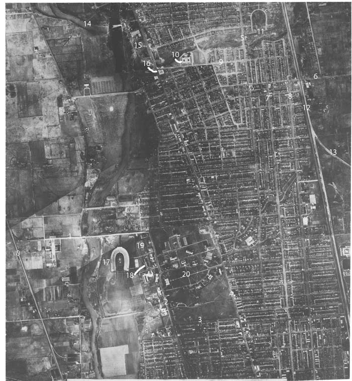
Expand
without key numbers -
Expand with key numbers
North is to the top
of the photograph
An aerial photograph taken in 1932 by
Student Curtis E. LeMay later to be General Curtis E. LeMay. This photo is a
mosaic made by LeMay for his graduate thesis requirement at Ohio State
University. The techniques he developed would later be used in World
War II.
There is a surprising amount of railroading taking place on this piece of
north side real estate. There are five streetcar lines, The CD&M
interurban and three steam railroads - the C&O, NYC - Big Four and PRR
- Sandusky Branch.
The streetcar lines include:
-
the North-South High Street line
that went north to Arcadia Avenue,
-
the Neil Avenue line that went north
to Eleventh Avenue on the south edge of OSU,
-
the Fourth Street line that went
north to Wyandotte Street,
-
the standard gauge Summit Street
line that went north on Summit swung over to Indianola Avenue at Hudson
and continued to Oakland Park Avenue (off picture to the north).
There was also service on the Summit Street line from Indianola
Avenue west on Arcadia Avenue then north on High Street to Worthington.
-
Finally there was the Chittenden
Avenue shuttle from High Street to the State fair grounds.
If this is all confusing check the
1927
Columbus Street Railway Map.
The Columbus Delaware & Marion Electric Co. interurban came from the north
along side the Big Four tracks on the Worthington cutoff .
Just before Hudson Street it turned west to Indianola Avenue south to
Hudson Street east one block to Summit Street and on south to
downtown Columbus.
The Chesapeake and Ohio Railroad delivered coal on a spur right down the
middle of Stadium Drive to the OSU power plant on the east side of the stadium.
On football game days as many as five passenger trains could be spotted
along this spur. Two fit along side the power plant in a small yard
normally used for the coal cars. One sat on the curve leading to
Stadium Drive and two were spotted in a small two or three track yard in
the middle of Stadium Drive. OSU had a diesel switcher
for moving the coal cars around.