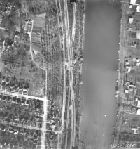
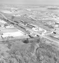
| Photo #1 - The
double track Pennsy Sandusky Branch is crossing the NYC "Big Four".
The Ohio Railway Museum track is to the left of the PRR/NYC track.
The Colonial Hills development is in the left bottom quarter of the
photo. Harding Hospital is left top quarter. Poste Lake
is shown. The south end of the lake (bottom of photo) is the
shallow end. The PRR dug this in the 1910's for fill.
The tracks entered the quarry from the south. During the dig a
spring was uncovered and the quarry became Poste Lake.
The top of the photo is north. |
 |
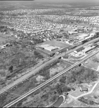
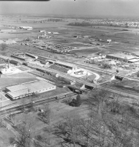
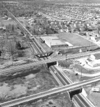
| Photo #2 - State
Route 161 is crossing under the ORM/PRR/NYC tracks. The north
end of Poste Lake is visible. The Potter Lumber Co. (now a
self storage business) is between the tracks. North of SR 161
between the ORM and PRR tracks is the Worthington Coal & Supply Co.
office, the old PRR depot being used as a section house, and the
long old PRR freight house. On the west of the ORM track
is the Nabisco warehouse and north of that the Worthington Foods Co.
The camera is pointed northwest |
 |
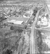
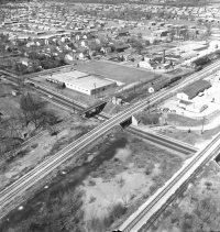
| Photo #3 - North of
the old PRR freight house is the coal yard and ORM car barn.
In the left top quarter is the Seventh Day Adventist Church and to
the right of that the Seventh Day Adventist Community Center.
In the far distance the switch for the north end of the NYC siding
is visible.
There are two very large and old oak trees one in the front yard
of the Worthington Foods plant and the other just north of Potter
Lumber where the PRR and NYC track start to come together. The
Camera is pointing north. |
 |
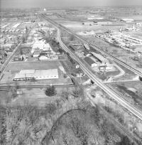
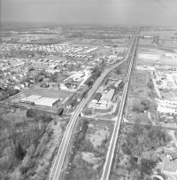
| Photo #4 - In the
bottom center of the photo can be seen Rush Creek going through the
Harding Hospital property. Rush Creek goes under the three
railroads. The Camera is pointed north |
 |
| Photo #5 - Camera
pointed north northeast. |
 |
| Photo #6 - The Rush
Creek culvert entranced under the ORM tracks is visible. The
Camera is pointed northeast |
 |
| Photo #7 - The
culvert that ran under the three railroads was open for a short
distance between the PRR and NYC tracks. At the very bottom of
the photo can be seen the open pit that led down to Rush Creek.
The camera is pointed northwest. |
 |
| Photo #8 - Rush
Creek can be seen on the east side of the NYC tracks. Rush
Creek came from the north. The overflow from Poste Lake also entered
Rush Creek at this point. In the very far distance can be seen
the Pontifical College Josephinum with its bell tower. The camera is
pointed north |
 |
| Photo #9 - The
camera is pointed west northwest along Route 161 toward central
Worthington. |
 |


